By Staff
Amidst day-to-day life, most of us do not consider the bigger picture in concern to the vitality of our planet. As the years pass and the planet spins round’, researchers and scientists bring up a concern that will affect every aspect of the very world we live in: Climate change, in particular, the impact of our heating planet on tidal systems.
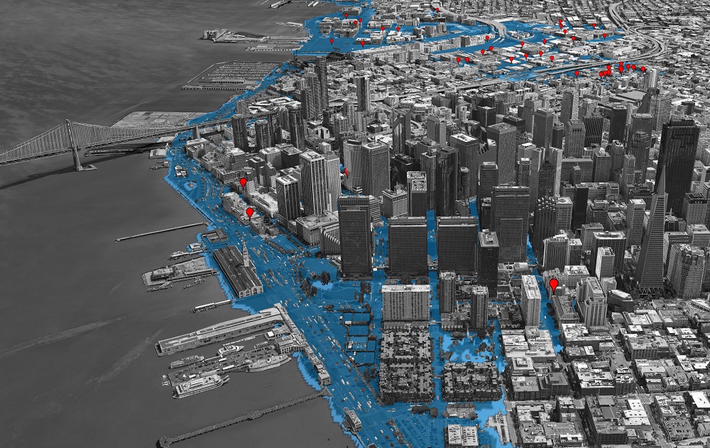
Living in the Bay Area means we have incredible views, vast nature, extensive biodiversity and of course, life right on the water, which though beautiful, is rapidly becoming a concern. Due to human activity and released emissions, sea levels in the next decade could rise a whole foot. This means that homes along the water are at an 80% chance of flooding. San Mateo County is particularly vulnerable, with over 30,000 homes, dozens of schools and hospitals, and over 7,000 acres of wetlands at risk of flooding by 2070.
When developing San Francisco, urban planners built the city into the shoreline, infiltrating the natural flow of the tides. Now, as rising sea levels become less of a concern and more of a sure reality, we can expect the shoreline to return to its original state, which is now partly urban land. This leaves the waterfront in the most danger.
What’s most important to understand is that though the risk seems remote, the process of executing the plan takes a long time. To protect the waterfront from rising sea levels, we must take action now.
Miles of historic sea wall along the urban edge need intervention, including ground improvements and safer buildings. The plan’s most drastic proposals include raising up roadways and certain structures, such as the ferry building, by 7 feet. If the draft plan is approved by Congress, the Federal Government may pay up to 65% of construction costs. Though just recently pitched, the plan is already underway. The earliest improvements we’ve seen is work being done at Pier 70.
Accommodation of industrial and military activities during World War 2 completely transformed our Bay edge. In 1960, ⅓ of the Bay had been filled in or diked off from the tides and there were plans to fill 60% of what was left. This would’ve left a narrow river, destroying all of the great environment the Bay Area has to offer. Luckily, environmentalists stepped in and warned of the threat this imposed upon everything.
We, just like those who came before us, have an opportunity to restore the shoreline of the beautiful Bay that houses us, and protect it against sea level rise which is coming. According to the plan, in just a few years the tidal marshes will start revegetating and will become a transition zone for native plants to flourish. If we are successful in the next decade, we can restore some wildlife back to sustainable levels and build communities that are resilient to sea level rise.
